Connect with us

Technology

Drone Market to Grow by USD 36.1 Billion from 2024-2028, Driven by Increased Drone Applications, Report on AI’s Impact on Market Landscape – Technavio

Published

on

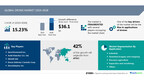
NEW YORK, Feb. 7, 2025 /PRNewswire/ — Report with market evolution powered by AI – The global drone market size is estimated to grow by USD 36.1 billion from 2024-2028, according to Technavio. The market is estimated to grow at a CAGR of over 15.23% during the forecast period. Rise in applications of drones is driving market growth, with a trend towards new developments and launches of commercial drones. However, restrictive laws and regulations governing uav use poses a challenge. Key market players include AeroVironment Inc., Autel Robotics Co. Ltd., DELAIR SAS, Drone Delivery Canada Corp., DroneDeploy Inc., EHang Holdings Ltd., Intel Corp., Kespry Inc., Kitty Hawk Corp., Leptron Unmanned Aircraft Systems Inc., Parrot Drones SAS, Pix4D SA, PrecisionHawk Inc., Skydio Inc., Spirit AeroSystems Inc., SZ DJI Technology Co. Ltd., Teledyne Technologies Inc., Terra Motors Corp., The Boeing Co., Trimble Inc., and Yuneec International Co. Ltd.

AI-Powered Market Evolution Insights. Our comprehensive market report ready with the latest trends, growth opportunities, and strategic analysis- View Free Sample Report PDF

Forecast period

2024-2028

Base Year

2023

Historic Data

2018 – 2022

Segment Covered

Application (Industrial, Terrestrial imagery and mapping, Precision agriculture, Inspection and monitoring, and Others), Type (Rotary blade, Fixed wing, and Hybrid), and Geography (APAC, North America, Europe, Middle East and Africa, and South America)

Region Covered

APAC, North America, Europe, Middle East and Africa, and South America

Key companies profiled

AeroVironment Inc., Autel Robotics Co. Ltd., DELAIR SAS, Drone Delivery Canada Corp., DroneDeploy Inc., EHang Holdings Ltd., Intel Corp., Kespry Inc., Kitty Hawk Corp., Leptron Unmanned Aircraft Systems Inc., Parrot Drones SAS, Pix4D SA, PrecisionHawk Inc., Skydio Inc., Spirit AeroSystems Inc., SZ DJI Technology Co. Ltd., Teledyne Technologies Inc., Terra Motors Corp., The Boeing Co., Trimble Inc., and Yuneec International Co. Ltd.

Key Market Trends Fueling Growth

Unmanned aircraft, also known as Unmanned Aerial Vehicles (UAVs) or Unmanned Aircraft Systems (UAS), are robots that fly without a human pilot on board. This market includes various types of drones, such as rotary wing and fixed wing, powered by heat engines, jet engines, or electrical engines. Trends in this industry include GPS technology for traffic monitoring, videography, agriculture, delivery services, weather monitoring, search and rescue, surveillance, military, and defense applications. Sensors like ultrasonic, laser, LIDAR, time-of-flight, chemical, stabilization, orientation, thermal, hyperspectral, and minerals play a crucial role in drone functionality. The agriculture segment, construction sector, real estate sector, and oil and gas industries are significant markets for commercial drones. Companies like AeroVironment Inc and Skydio lead in this sector. Drones are used for various purposes such as aerial videography, photography, flora and fauna, public services, thermal imaging cameras, and precision agriculture applications. The market is expanding into sectors like e-commerce, border security, energy, insurance industries, and military capabilities. Regulations and subsidy programs are shaping the industry’s growth. 

Drones have transformed the commercial sector due to their ease of deployment, minimal maintenance costs, mobility, and ability to hover. They are extensively used in various industries such as wireless coverage and remote sensing, search and rescue operations, delivery services, security and surveillance, precision agriculture, and civil infrastructure inspection. In emergency situations like natural or man-made disasters, drones play a crucial role in expediting rescue efforts. They can quickly survey vast areas during disasters like floods, wildfires, and avalanches, providing essential data for effective response planning. Additionally, drones can transport medical supplies to inaccessible areas and offer timely disaster warnings, enhancing overall disaster management efforts. 

Insights on how AI is driving innovation, efficiency, and market growth- Request Sample!

Market Challenges

The Drone Market encompasses various unmanned aircraft, aerial vehicles, and systems, collectively referred to as drones. These robotic flying machines employ GPS technology for traffic monitoring, videography, agriculture, delivery services, and weather monitoring, among others. Challenges in sectors like agriculture, construction, real estate, and public services, have led to the integration of drones in mining, oil and gas, transportation, entertainment, telecommunications, and more. Drones incorporate sensors such as ultrasonic, laser, LIDAR, time-of-flight, chemical, stabilization, orientation, and thermal sensors. Companies like Skydio, AeroVironment Inc, and Raptor Maps lead the market with innovations in drone technology, including autonomous drones, precision agriculture applications, and filming and photography. The hybrid segment caters to the e-commerce sector, border security, and military operations. Regulations and subsidy programs influence the market’s growth, while hobbyist drones cater to individual users. Drones offer solutions in various industries, including infrastructure, energy, insurance, military capabilities, and the political arena.Drones, although offering numerous business applications, pose a significant security concern due to their misuse by criminals and terrorists. The ease of access to drone technology and lax regulations increase the risk of drones being used for nefarious activities, such as terror attacks or surveillance of sensitive areas. To mitigate these risks, governments are implementing stricter regulations. These regulations include mandatory type certification for drones, obtaining a drone pilot license for operators, and completing training from authorized remote pilot training organizations. These measures aim to minimize the potential for drones to be used for criminal or terrorist activities.

Insights into how AI is reshaping industries and driving growth- Download a Sample Report

Segment Overview 

This drone market report extensively covers market segmentation by

ApplicationIndustrialTerrestrial Imagery And MappingPrecision AgricultureInspection And MonitoringOthersTypeRotary BladeFixed WingHybridGeographyAPACNorth AmericaEuropeMiddle East And AfricaSouth America

1.1 Industrial- The industrial sector is experiencing significant growth in the use of drones due to their efficiency and safety benefits. Real-time aerial inspections enable quick assessment of construction sites, reducing potential hazards by 91%. Autodesk, a leading software company in architecture and construction, has invested in drone manufacturer 3D Robotics since 2018. Their collaboration offers a UAV-to-cloud solution, allowing drone data to be analyzed using Autodesk software. Additionally, drones act as portable communication towers during emergencies or large events, enhancing network capacity. These factors are fueling the demand for drones in industrial applications.

Download complimentary Sample Report to gain insights into AI’s impact on market dynamics, emerging trends, and future opportunities- including forecast (2024-2028) and historic data (2018 – 2022) 

Research Analysis

Unmanned aircraft, also known as Unmanned Aerial Vehicles (UAVs) or Unmanned Aircraft Systems (UAS), are robotic aircraft that operate without a human pilot on board. These flying machines have gained significant attention in various industries due to their versatility and capabilities. UAVs are used for traffic monitoring, videography, agriculture, delivery services, weather monitoring, search and rescue, and more. In the commercial sector, they are employed in real estate, construction, and inspection of unstable roofs and electrical cables. UAVs are equipped with GPS, computing, microcontrollers, and processors for navigation and data processing. They have applications in defense and border security, with autonomous drones used for precision-guided bombs and missiles in military operations. Aerial photography and video recording are common applications, while surveying and mapping are also popular uses for UAVs.

Market Research Overview

Unmanned aircraft, also known as Unmanned Aerial Vehicles (UAVs) or Unmanned Aircraft Systems (UAS), refer to robotic aircraft that operate without a human pilot on board. These robots use Global Positioning System (GPS) technology for navigation and can be employed in various sectors for traffic monitoring, videography, agriculture, delivery services, weather monitoring, search and rescue, surveillance, military, and defense applications. UAVs come in different forms such as rotary wing drones and fixed wing drones, and can be powered by heat engines, jet engines, or electrical engines. They are equipped with sensors including ultrasonic, laser, LIDAR, time-of-flight, chemical, stabilization, orientation, thermal, hyperspectral, and various types of cameras. The agriculture segment, construction sector, real estate sector, and oil and gas industries are significant users of UAVs for crop health monitoring, surface composition analysis, and infrastructure inspections. UAVs are also used in public services, transportation, entertainment and media, telecommunications, mining, and construction industries. Autonomous drones are increasingly being used for military operations, video recording, surveying, logistics, retail organizations, emergency response, and even in the political arena. UAVs are also used in hobbyist applications and can be used for infrastructure inspections, energy sector monitoring, insurance industries, and military capabilities. Regulations and subsidy programs play a crucial role in the drone market. UAVs are also used for anti-aircraft target practice, artillery spotting, intelligence gathering, and weather monitoring. UAVs can be equipped with sensors such as ultrasonic sensors, laser sensors, LIDAR sensors, time-of-flight sensors, chemical sensors, stabilization sensors, orientation sensors, thermal sensors, and hyperspectral sensors. The drone market is expected to grow significantly in the coming years due to the increasing demand for UAVs in various industries and applications.

Table of Contents:

1 Executive Summary
2 Market Landscape
3 Market Sizing
4 Historic Market Size
5 Five Forces Analysis
6 Market Segmentation

ApplicationIndustrialTerrestrial Imagery And MappingPrecision AgricultureInspection And MonitoringOthersTypeRotary BladeFixed WingHybridGeographyAPACNorth AmericaEuropeMiddle East And AfricaSouth America

7 Customer Landscape
8 Geographic Landscape
9 Drivers, Challenges, and Trends
10 Company Landscape
11 Company Analysis
12 Appendix

About Technavio

Technavio is a leading global technology research and advisory company. Their research and analysis focuses on emerging market trends and provides actionable insights to help businesses identify market opportunities and develop effective strategies to optimize their market positions.

With over 500 specialized analysts, Technavio’s report library consists of more than 17,000 reports and counting, covering 800 technologies, spanning across 50 countries. Their client base consists of enterprises of all sizes, including more than 100 Fortune 500 companies. This growing client base relies on Technavio’s comprehensive coverage, extensive research, and actionable market insights to identify opportunities in existing and potential markets and assess their competitive positions within changing market scenarios.

Contacts

Technavio Research
Jesse Maida
Media & Marketing Executive
US: +1 844 364 1100
UK: +44 203 893 3200
Email: media@technavio.com
Website: www.technavio.com/

View original content to download multimedia:https://www.prnewswire.com/news-releases/drone-market-to-grow-by-usd-36-1-billion-from-2024-2028–driven-by-increased-drone-applications-report-on-ais-impact-on-market-landscape—technavio-302370835.html

SOURCE Technavio

Continue Reading

Technology

Trimble for Government Achieves ‘Initial Implementation’ Status for FedRAMP Class C (Moderate) Certification

Published

on

By

Milestone accelerates secure cloud adoption for federal, state and local entities managing infrastructure, spatial data and capital assets 

WESTMINSTER, Colo., Oct. 20, 2026 /PRNewswire/ — Trimble today announced that Trimble for Government is listed as ‘Initial Implementation’ status for Federal Risk and Authorization Management Program (FedRAMP®) Class C (Moderate) certification and is now listed on the FedRAMP Marketplace. In conjunction with seeking FedRAMP certification, Trimble is also pursuing GovRAMP authorization to support state, local and education (SLED) customers with reciprocal cybersecurity compliance standards.

This dual milestone marks a critical step forward in delivering a software as a service (SaaS) cloud environment built within a secure Government Community Cloud. Designed specifically for U.S. Federal Government departments, state and local agencies, and defense and civilian contractors, Trimble for Government provides a unified ecosystem for managing infrastructure, spatial data, capital projects, permitting and facility assets across their entire lifecycle.

Achieving FedRAMP Class C (Moderate) and GovRAMP alignment will enable public sector entities and Department of Defense (DoD) contractors to comply with stringent security mandates — including Cybersecurity Maturity Model Certification (CMMC) alignment — while modernizing digital engineering and asset management.

“Federal, state and local agencies face the dual challenge of modernizing critical infrastructure while maintaining uncompromising cybersecurity standards,” said Mark Schwartz, group president, AECO at Trimble. “Achieving ‘Initial Assessment’ status reflects our commitment to delivering mission-critical spatial, capital project and asset management capabilities inside a secure, audit-ready cloud boundary across all levels of government.”

Integrated cloud solutions built for government operations

The in-scope environment brings together Trimble’s proven field execution, asset, project and permitting software into four modular packages designed to support specific public sector outcomes:

Trimble® Field Collaboration: Delivers field data services using foundational spatial database infrastructure and GIS integration to support high-security field operations, map assets, and enable seamless field-to-cloud workflows across Trimble’s core Field Systems portfolio.Trimble Project Management powered by Trimble ProjectSight® software: Connects design-to-build workflows in the field, providing precision data layout, project tracking, collaboration and quality assurance across construction projects.Trimble Asset Management powered by Trimble Unity™ Maintain software: Serves as a centralized facilities data core for federal, state, and local government agencies, military installations, and public infrastructure — such as public buildings, utilities, and transportation networks — to optimize maintenance and long-term capital planning.Trimble Permit Management powered by Trimble Unity Permit software: Streamlines end-to-end management of permitting, licensing, land use and infrastructure rights-of-way in a fully compliant cloud environment.

The unifying in-scope element across all four packages is the Trimble Connect® platform, providing collaboration and a common data environment (CDE) across the Trimble for Government platform.

With assessment processes underway, Trimble continues to advance toward full FedRAMP and GovRAMP authorizations to ensure public sector customers can innovate with confidence.

About Trimble
Trimble is a global technology company that connects the physical and digital worlds, transforming the ways work gets done. With relentless innovation in precise positioning, modeling and data analytics, Trimble enables essential industries including construction, geospatial and transportation. Whether it’s helping customers build and maintain infrastructure, design and construct buildings, optimize global supply chains or map the world, Trimble is at the forefront, driving productivity and progress. For more information about Trimble, visit: www.trimble.com.

GTRMB

View original content to download multimedia:https://www.prnewswire.com/news-releases/trimble-for-government-achieves-initial-implementation-status-for-fedramp-class-c-moderate-certification-302913499.html

SOURCE Trimble

Continue Reading

Technology

Delta Development Team and The Good Drone Company Awarded U.S. Army Contract for Aerial Blood Delivery

Published

on

By

TUCSON, Ariz., Oct. 20, 2026 /PRNewswire/ — Delta Development Team (DDT), a leader in prehospital blood storage and cold chain technology, and The Good Drone Company (GDC) have been awarded a U.S. Army contract to develop a drone-based blood delivery capability for the Army Blood Link (ABL) program.

The program is part of the broader Armed Services Blood Program (ASBP), which supplies blood products to U.S. military forces worldwide. Army Blood Link is designed to support battlefield medical logistics through rapid, temperature-controlled delivery of lifesaving blood products to the field, providing an additional resupply option when traditional ground transportation is unavailable, delayed, or unsafe. Under the contract, The Good Drone Company will provide two U.S.-built prototypes of its hybrid vertical takeoff and landing (VTOL) cargo drone, each designed to transport up to six units of blood, while DDT will provide the temperature-controlled storage capability through its Delta ICE 2L Smart Blood Cooler.

The companies are combining commercial off-the-shelf (COTS) technologies to create a U.S.-sourced aerial blood delivery system capable of transporting blood directly to the point of need.

To meet ABL program requirements, DDT will supply six Delta ICE 2L Smart Blood Coolers, each designed to maintain two units of blood within the required temperature range for three hours of aerial delivery in high-humidity environments with ambient temperatures ranging from 15°F to 120°F. Built-in temperature monitoring and data recording, along with Bluetooth and cellular connectivity, support cold-chain oversight and blood accountability. The program extends DDT’s blood storage and monitoring capabilities into aerial delivery.

“Getting blood to the point of need is only part of the challenge. It must also remain within the required temperature range throughout the journey,” said Montgomery Leija, CEO of Delta Development Team. “This program brings DDT’s experience in blood storage and cold chain management into a new operational environment, taking the blood supply chain from the ground to the air.”

The prototype system is designed to deliver blood within 10 meters of a designated target during both day and night operations. It will feature a communications range of up to 30 miles and semi-autonomous waypoint navigation. It is intended for single-person operation with minimal training and is built on GDC’s existing commercial cargo drone technology to accelerate development and fielding while meeting U.S.-sourcing requirements.

“We have seen strong interest in middle-mile drones in emerging markets for some time, from both public and private sector customers spanning healthcare to third-party logistics,” said Jake Vander Ploeg, CEO of The Good Drone Company. “This program is a great example of how the military is adopting commercial technology like our cargo drones to quickly test new ideas in the field without starting a full aircraft development program.”

The collaboration combines GDC’s expertise in commercial drone platforms and aerial delivery with DDT’s temperature-controlled blood storage and transport capabilities to support:

Rapid resupply: Delivering blood when conventional ground transportation is unavailable or unsafe.Cold chain protection: Maintaining required blood temperatures during aerial transport.U.S.-sourced capability: Supporting domestic defense supply chain objectives.Accelerated development: Combining GDC’s existing commercial cargo drone technology with DDT’s established blood storage solutions.

The ABL effort addresses the challenge of delivering critical medical supplies in contested and austere environments. When terrain, damaged infrastructure, or tactical conditions prevent conventional resupply, aerial delivery combined with temperature-controlled storage can expand options for getting lifesaving blood products to service members when and where they are needed.

About Delta Development Team

Delta Development Team (DDT) is a U.S.-based medical technology company headquartered in Tucson, Arizona, specializing in blood storage, transport, monitoring, and logistics solutions for military and prehospital environments. DDT develops technology designed to keep blood available, traceable, and mission-ready from the blood bank to the point of injury. Its portfolio includes the APRU 6L, Delta ICE 2L, TBS 40L, and BloodCOMM® blood management platform.

Media Contact: info@deltadevteam.com | www.deltadevteam.com

About The Good Drone Company

The Good Drone Company (GDC) is an aerospace company headquartered in Tempe, Arizona, that designs and builds autonomous hybrid VTOL cargo drones for middle-mile logistics. GDC’s aircraft take off and land vertically without a runway, carry up to 55 lb (25 kg) of payload, and fly more than 300 miles (500 km) at speeds up to 93 mph (150 km/h). GDC is deploying in Kenya to close the middle-mile transportation gap for public and private sector customers, working closely with its local partner ThatcherX and the Kenyan government to change how goods move around the country.

Media Contact: info@thegooddronecompany.com | www.thegooddronecompany.com

View original content to download multimedia:https://www.prnewswire.com/news-releases/delta-development-team-and-the-good-drone-company-awarded-us-army-contract-for-aerial-blood-delivery-302913294.html

SOURCE Delta Development Team

Continue Reading

Trending